
Hamilton Conservation Authority Resources
Membership dollars play a crucial role in protecting, preserving, and restoring ecosystems and heritage sites within the HCA watershed. By becoming an HCA Member, you will enjoy the benefits of the great outdoors, and safeguarding these areas for future generations.


HCA and its Watersheds
A brief history of HCA
The origins of the conservation movement and conservation authorities in Ontario dates to the early 1900s. It was during this period that some individuals and organizations began to take notice of deteriorating environmental conditions, including pollution, deforestation, flooding and soil erosion. These conditions were the result of over a hundred years of settlement in Ontario and an associated legacy of poor land and natural resource management practices in some regions. The conservation movement that began during this period would eventually lead to a number of important conservation milestones, including passing of the Conservation Authorities Act in 1946.
Growth and development in the Townships of Puslinch, Flamborough, Beverly, Ancaster and Dundas in the 1950s eventually led to concern among residents over conservation issues, including summer creek flows, flooding, reforestation and recreation. These communities petitioned the province under the Conservation Authorities Act to establish a watershed unit charged with the management of water resources. That request was approved, and the Spencer Creek Conservation Authority was founded on May 8, 1958, and held its first meeting on June 20, 1958. The Spencer Creek watershed included an area of approximately 25,000 ha extending from the Township of Puslinch to Hamilton Harbour.
In an effort to temper growth with some greater consideration for the environment, the City of Hamilton and parts of the surrounding communities of Stoney Creek, Saltfleet, Binbrook, and Glanford decided to join the Spencer Creek Conservation Authority in 1966, which resulted in the creation of the Hamilton Region Conservation Authority. In 2000, with the amalgamation of municipalities in the Hamilton region, the name of the conservation authority was changed to the Hamilton Conservation Authority (HCA) for administrative purposes, but remains Hamilton Region Conservation Authority in law.
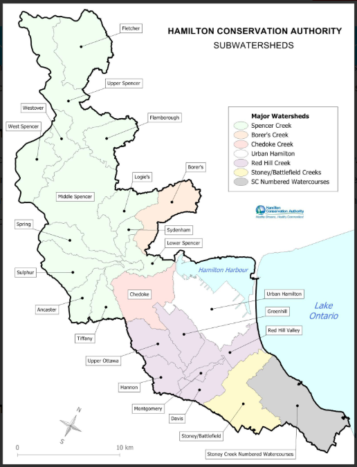
Today, the HCA watersheds cover an area of approximately 57,000 ha (570 sq km), that includes portions of the Town of Grimsby, the City of Hamilton, and the Township of Puslinch in Wellington County (Figure 1). Within the watersheds under its jurisdiction, HCA administers programs and services to further the conservation and management of natural resources. This includes programs to manage water resources, protect people and property from natural hazards, monitor and conserve the natural environment, and provide recreational and educational opportunities. The HCA works collaboratively with a variety of agencies and groups in implementing its programs and services, and in support of its vision for a healthy watershed for everyone.
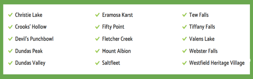
In support of its mandate, the HCA owns and manages approximately 4,700 ha of land. This includes large areas of conservation land that support important natural heritage features and ecological and hydrological functions, and which provide for passive recreational use. The HCA also operates a number of Conservation Areas with facilities and infrastructure that provide for a wide range of recreational uses, educational programming and events. The HCA is governed by a Board of Directors, which consists of 10 members appointed by the City of Hamilton, 7 elected officials and 3 citizen appointments, and 1 member from the Township of Puslinch. Funding for HCA’s programs comes primarily from municipal levy and revenues that are self-generated.
Wetlands are among the most productive and biologically diverse habitats on earth. They provide critical ecological and hydrologic functions, ecosystem services, and socio-economic benefits. Wetlands retain water during periods of high-water levels or peak flows (i.e. spring freshet and storm events), allowing the water to be slowly released into watercourses, infiltrate into the ground, and for evapotranspiration. These processes provide natural flood attenuation and reduce the energy associated with flood waters, helping to mitigate the impacts of flooding and erosion.
Wetlands also release water during times of drought to maintain base flows in streams and creeks. Improvement of water quality, provision of habitat for a wide variety of plant and animal species, climate change mitigation and the provision of recreational opportunities are further benefits that wetlands support. The areas adjacent to wetlands also play an important role in supporting and maintaining the function of wetlands.
Development and other activities that may occur within or adjacent to wetlands have the potential to impact the condition and hydrologic functions of wetlands, and result in adverse impacts to flooding and erosion hazards. Wetlands may also contain unstable (organic) soils, which are considered hazardous lands and can present risks to public safety and property. The policies set out in this section are intended to protect, maintain and restore wetlands within the watershed.
Wetland Policies
Defining Wetland Regulation Limits
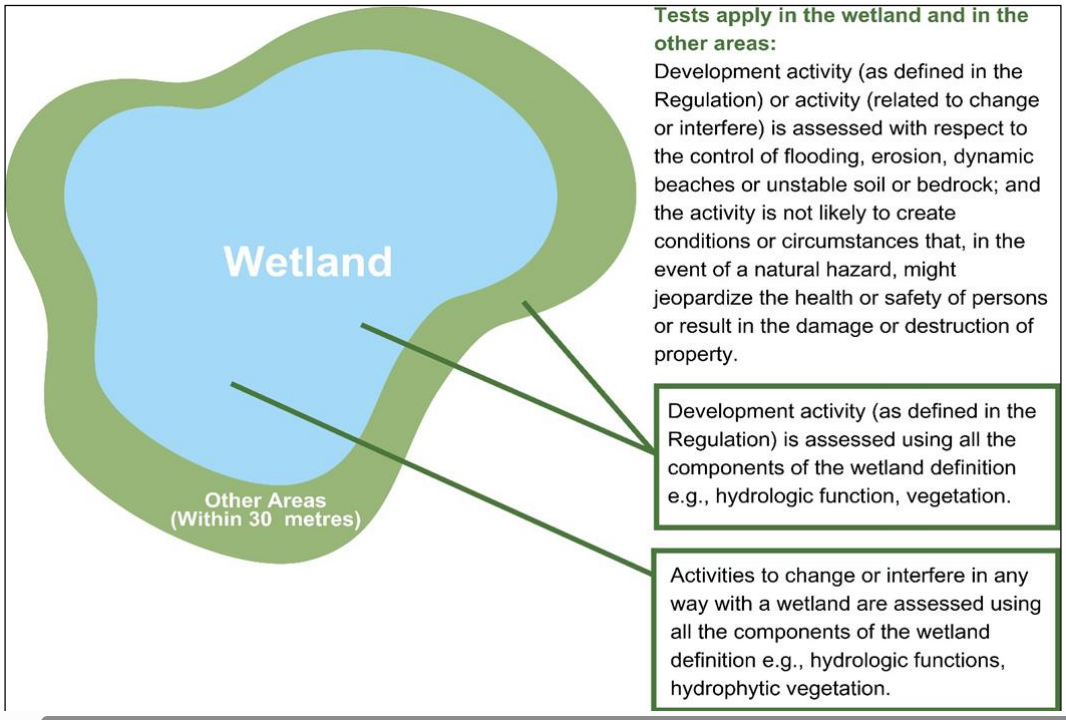
For the purposes of Section 28 of the Conservation Authorities Act and the prohibition of certain activities in wetlands or areas adjacent to wetlands, O. Reg. 41/24 defines a wetland as land that:
a) is seasonally or permanently covered by shallow water or has a water table close to or at its surface,
b) directly contributes to the hydrological function of a watershed through connection with a surface watercourse,
c) has hydric soils, the formation of which has been caused by the presence of abundant water, and
d) has vegetation dominated by hydrophytic plants or water tolerant plants, the dominance of which has been favoured by the presence of abundant water.
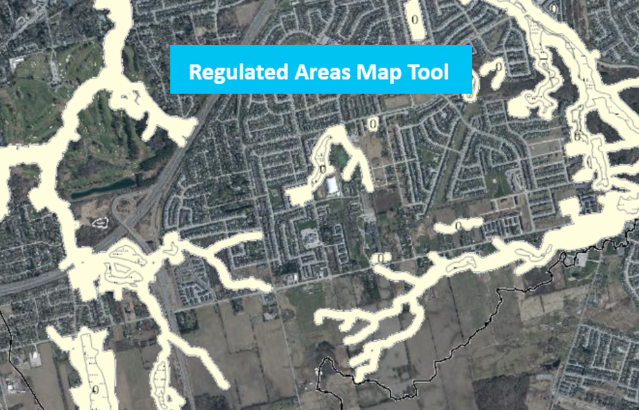
The definition of wetland does not include periodically soaked or wet land used for agricultural purposes which no longer exhibits a wetland characteristic referred to in clause (c) or (d) of that definition. The areas adjacent to wetlands are considered to be all lands within 30 m of wetlands and are referred to as ‘other areas’. No person shall carry out development activities in areas that are within an authority’s area of jurisdiction and are within 30 metres of a wetland.
Source: Section 5.6.1
General Policies
In carrying out its regulatory functions and responsibilities under the Conservation Authorities Act HCA has the following objectives:
• Protect people and property from risks associated with natural hazards;
• Raise awareness regarding natural hazards and their associated risks;
• Manage natural hazards on a watershed basis, and in accordance with provincial standards and accepted best practices;
• Direct development activity to areas outside of hazardous lands wherever possible;
• Prevent interference with watercourses and wetlands to protect their hydrologic functions and contributions to the control of flooding and erosion; and
• Protect water resource systems and natural heritage systems where they contribute to the control, management or mitigation of risks and impacts associated with natural hazards.
Source: Section 5.1
Policies defined in Section 5 of the CA Act include any direct, indirect or cumulative impact or change resulting from a development activity or interference that would have the effect of creating or altering hazardous conditions, increasing risks related to or resulting from any natural hazard, or hindering the ability to manage or mitigate risks associated with any natural hazard.
Source: Section 5.1.3