
Wetlands 101
What is a wetland?
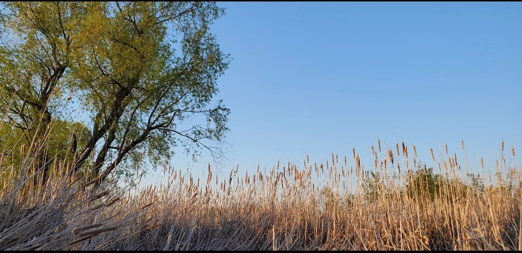
Ontario's wetlands have distinguishing characteristics as biologically diverse ecosystems that are flooded by water permanently or seasonally. They are classified by the dominant plants and/or source waters that define them:
• A marsh contains emergent vegetation such as reeds, cattails and sedges
• Swamps are dominated by woody vegetation such as trees and shrubs
• Water sources of wetlands include tidal, estuary (tidal & river), flood plains, springs, seeps and fens (groundwater discharge), bogs and vernal ponds (rainwater or meltwater)

The Importance of wetlands
Wetlands lie at the junction between terrestrial (earthly) and aquatic (in or near water) habitats,and therefore provide a natural home for a diverse array of organisms and species. They play a vital role in protecting biodiversity.
“This makes wetlands among the most dynamic, biologically diverse and productive ecosystems on the planet.”
- Ontario Biodiversity Council
The benefits from wetlands are varied and numerous, and they provide important services both to the environment and to human health. Wetlands are of critical importance for water filtration and purification, flood retention and erosion control, and shoreline stabilization.
Wetlands act as carbon sinks by helping to limit the escape of greenhouse gases into the atmosphere. Southwestern Ontario is entirely within an ecozone, containing a rich diversity of wetlands, owing to the presence of the Great Lakes. Point Pelee National Park and Long Point, both on Lake Erie, are nationally significant wetlands. Vast numbers of waterbirds use these wetlands during migration and they provide important habitats for fish. All remaining wetlands in Southern Ontario are vital for the conservation of wild species.
Loss of wetlands
“Southern Ontario has lost nearly three-quarters of its wetlands in the last two centuries, and wetland loss continues today. Despite years of promises, the government continues to allow the loss of the few wetlands we have left.” (Environmental Commissioner of Ontario) There are several reasons why this loss is happening.
Wetlands in general, receive no protection in Ontario until they are designated 'provincially significant.
The process to arrive at this designation is slow and often inefficient, and according to the Environmental Commissioner of Ontario in her 2018 Report, contains a “260 year backlog ... Instead, all unevaluated wetlands should be protected (presumed significant) until proven otherwise.”

Wetland conversion by ecodistrict. a. total wetlans loss; b. %loss - agriculture land use conversion; c. % loss - development land use conversion; d. % natural land cover. Source: Environmental Commissioner of Ontario, Back to Basics (2018)

Wetland Loss as a proportion of remaining wetlands in Southern Ontario. Source: Environmental Commissioner of Ontario, Back to Basics (2018)
Threats today
Environmental Defence clearly outlines the main threats to wetlands in southern Ontario - “Development of natural areas is the primary cause of wetland loss ... This occurs as a result of expanding residential and commercial development around cities and towns.”
Development industries have, and still are, resisting the protection of wetlands, and instead advocate for 'offsetting' programs. This means they can destroy a wetland and pay into a fund to try and 'create' a wetland elsewhere. Science itself questions the feasibility of re-creating any wetlands that will approximate their natural existence.
Meanwhile, the current Ontario PC government has been moving to put in place new rules to allow the development industry to create new 'offset' regimes, and lessen the protection of Ontario's wetlands.

What is a Watershed?
A Watershed or Drainage Basin is any area of land where precipitation collects and drains off into a common outlet, such as into a river, bay, or other body of water. The drainage basin includes all the surface water from rain runoff, snowmelt, hail, sleet and nearby streams that run downslope towards the shared outlet, as well as the groundwater underneath the earth’s surface.
The Ancaster Creek Subwatershed is a local watershed of significance
The headwaters of the Ancaster Subwatershed are situated in Mount Hope, the highest point between Lake Erie and Lake Ontario and as the early settlers recognized its significance as the highest point, they named it “Mount” Hope; waters of this great watershed head north, flowing down the escarpment into the coastal waters of Cootes Paradise and eventually into Lake Ontario.
The Ancaster Subwatershed encompasses an area of 13.7 km2 and is comprised of 6 catchment basins: Headwaters, Fiddler’s Green, Hamilton Golf and Country Club, Upper Valley, Lower Valley and Lower Ancaster Creek and Ancaster Creek is 34 km in length.
For more detailed information please refer to the Ancaster Creek Subwatershed Stewardship Action Plan
What is a Conservation Authority?
95% of Ontario's population lives in a watershed managed by a Conservation Authority. In Ontario, there are 36 watersheds, each managed by a Conservation Authority whose remit may cross multiple municipalities as the watershed boundaries are strictly geographical and not political.
Conservation Authorities are either charitable or nonprofit organizations legislated under the Conservation Authorities Act, 1946. Each Conservation Authority has its own Board of Directors comprised of members appointed by local municipalities and most are elected municipal officials. In 1954, the devastating storm Hurricane Hazel mobilized the need for managing Ontario’s watersheds on a regional basis. As a result of Hurricane Hazel, the provincial government amended the Conservation Authorities Act to enable Conservation Authorities to acquire lands for recreation and conservation purposes, and to regulate that land for the safety of the community.
What is a Stormwater Management Pond?

Stormwater Management Ponds (SWMPs) are facilities designed to collect runoff from concrete surfaces and the local storm sewer system following either a rainfall or snowmelt event, or activities such as watering lawns and washing cars. They are required to be built by developers in urban areas as flooding and erosion control measures. Stormwater ponds collect rainwater (stormwater runoff) that runs over impermeable surfaces such as parking lots, roads, and buildings, and which has collected contaminants such as road salt along the way. In some cases local wildlife will make a home in a SWMP but this is never an ideal situation as these ponds are full of pollutants and need to be dredged every few years. This disturbance can seriously disrupt wildlife who have moved in and made these contaminated ponds their home. The Spec: Dundas pond dredging disturbs at-risk turtles